Badsa Master Plan 2041 — Urban Development
बाड़सा मास्टर प्लान 2041 — आरोग्य धाम
Serving Badsa, Mandkola, Mundakhera and nearby Jhajjar villages
Investment
Infrastructure investment phased — official figure not published
Target Date
Phased up to 2041
Authority
DTCP Haryana (Town & Country Planning Department)
Area Served
Badsa, Mandkola, Mundakhera and nearby Jhajjar villages
About This Project
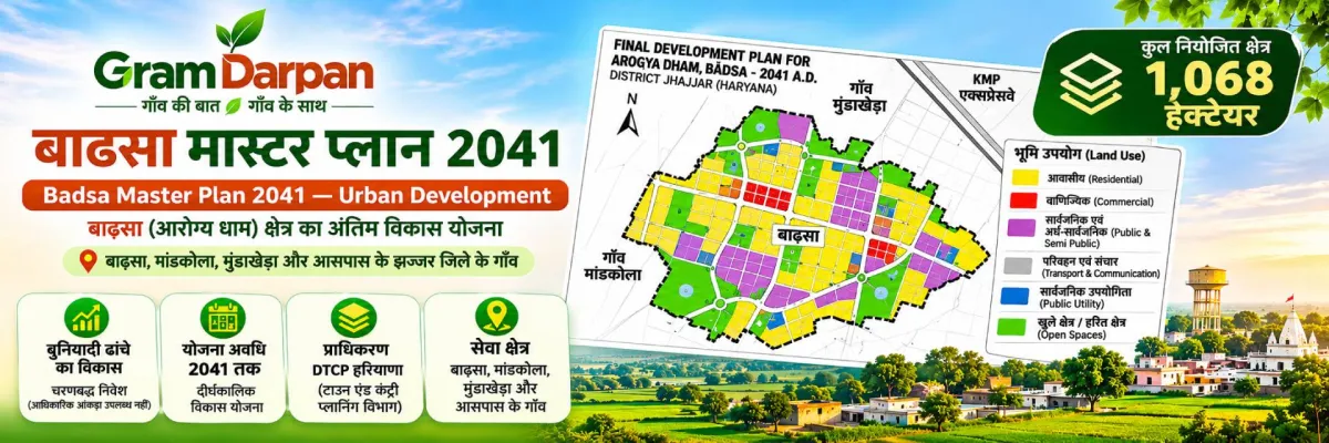
Badsa Master Plan 2041 — Planned Urban Growth Around Mundakhera
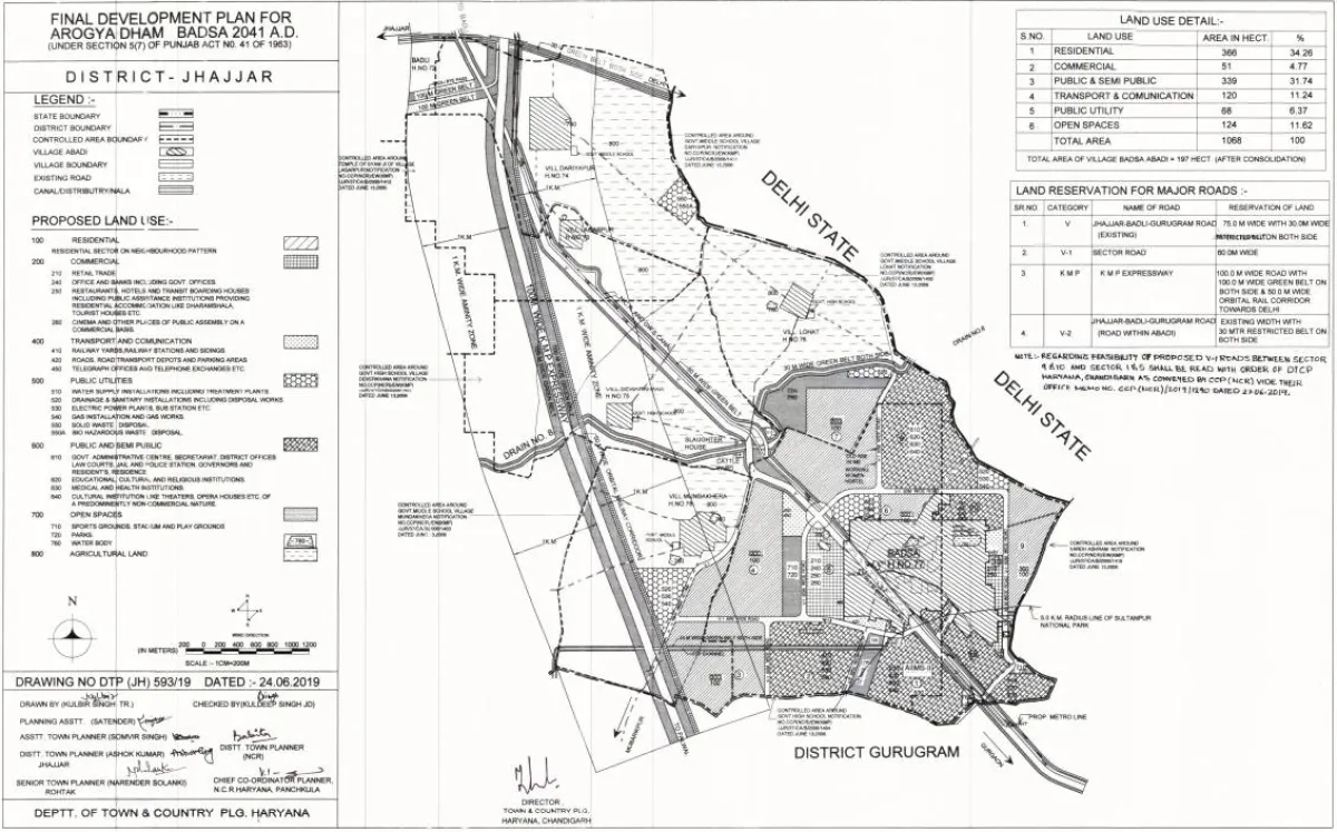
The Arogya Dham Badsa Master Plan 2041 is the Final Development Plan (FDP) for Badsa in Jhajjar district, prepared by the Town & Country Planning Department (DTCP), Haryana. It decides where residential sectors, commercial areas, roads, green belts and public institutions will come up around Badsa — the growth zone that Mundakhera and the neighbouring villages sit next to. In simple words: it tells farmers, plot buyers and the Panchayat what is allowed on which land.
Plan at a Glance
Plan name | Arogya Dham Badsa Master Plan 2041 (FDP) |
Prepared by | DTCP Haryana (NCR planning) |
Gazette reference | CCP(NCR)/FDP/Badsa/2019/1601, dated 9 Aug 2019 (as reported — verify on tcpharyana.gov.in) |
Planning area | Approx. 1,085 hectares (≈ 2,680 acres), six land-use zones |
Planning horizon | Up to 2041 |
Location | Badsa, Jhajjar — beside the KMP Expressway |
How the Land Is Planned
Public & semi-public use — over 32%: mainly the NCI-AIIMS (National Cancer Institute) campus and related health and institutional land.
Residential — about 35.6% (≈ 386 hectares): planned residential sectors, where DDJAY-style affordable plotted colonies are being licensed.
Commercial, industrial-support, transport and open/green areas: the remaining zones for markets, utilities, roads and parks.
KMP Expressway corridor: a 100 m wide reserve with 100 m green belts on both sides — no residential or commercial construction is permitted inside this buffer.
Why It Matters for Mundakhera
Badsa is where two very large projects meet — the NCI-AIIMS campus and the Reliance MET City industrial township. A notified plan means roads, sewerage, water and power can be planned in advance, licensed colonies get a legal framework, and nearby villages like Mundakhera gain access to jobs, healthcare and better connectivity. At the same time, land inside the plan has defined uses, so owners should check their khasra's zone before selling, buying or building.
What Villagers and Plot Buyers Should Do
Check your khasra / rectangle number against the plan on the DTCP Haryana portal or with the District Town Planner, Jhajjar.
Buy only in licensed colonies — verify the licence number on tcpharyana.gov.in and the project on Haryana RERA.
Do not build or sell plots inside the expressway green belt or outside a licensed/approved layout.
Keep copies of jamabandi, mutation and registry documents safe before any transaction.
Disclaimer: This page is informational and not an official DTCP page. Figures are summarised from published plan information and may be revised — always confirm zoning, licences and approvals with DTCP Haryana, HRERA and the District Town Planner before any land or property decision.
Key Benefits / Impact
- 1 Legal land-use zoning for Badsa and the surrounding growth belt
- 2 About 35.6% of the planning area earmarked for residential sectors
- 3 Over 32% reserved for public use — NCI-AIIMS cancer campus and institutions
- 4 100 m KMP Expressway reserve with 100 m green belts on both sides
- 5 Roads, sewerage and water to be planned ahead of licensed colonies
- 6 Safer plot buying — licensed DDJAY colonies instead of unplanned cutting
Project Documents (1)
Official reports and reference documents for this project — preview instantly or download to keep.
Frequently Asked Questions
Common questions about this project.
Project Details
- Category
- Governance & Planning
- Status
- Approved
- Authority
- DTCP Haryana (Town & Country Planning Department)
- Investment
- Infrastructure investment phased — official figure not published
- Completion
- Phased up to 2041
- Area
- Badsa, Mandkola, Mundakhera and nearby Jhajjar villages
Share
Have a Question About This Project?
Send us your query about Badsa Master Plan 2041 — Urban Development — pricing, eligibility, timelines, anything. The panchayat team will get back to you.